Here at Just History Posts I love sharing a plethora of incredible historical objects, and the Hereford Mappa Mundi is a true marvel to behold. It has been described as being “without parallel the most important and most celebrated medieval map in any form, the most remarkable illustrated English manuscript of any kind”. So why does it deserve such glowing praise?

Mappa mundi is the Latin name for “map of the world” and the term refers specifically to medieval European maps of this type. About 1,100 such maps are known to survive from this period of history, though the vast majority of these maps are found within manuscripts. Around 200 exist as stand-alone maps as we may picture today. At this time, maps were not necessarily intended to be exact diagrams to be used as navigational tools. Maps often combined existing knowledge of geography with religious iconography and locations, as well as mythical creatures thought to exist on the edges of reality.
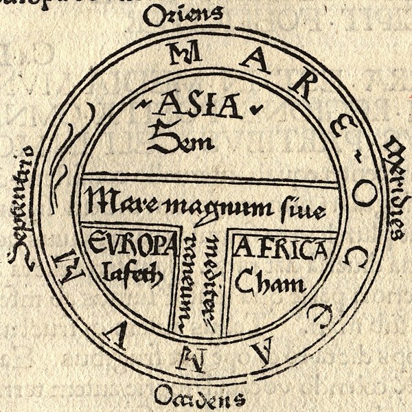
As these maps were not conforming strictly to geography as modern maps tend to, they often fell into certain categories. The Hereford Mappa Mundi is drawn in a way known as a “T and O map”. These T and O maps depict the world as it was described by the famous 7th-century scholar Isidore of Seville whose writings were highly regarded in the medieval period. These types of maps took a circle and divided it into 3 portions by drawing a T inside it. The 3 portions then represented the 3 known landmasses as understood by medieval Europeans: Europe, Asia, and Africa.
Unlike common perception, most people in the medieval period did indeed understand that the Earth is round. The T and O map was used to represent the known world but it was thought to be just one half of the Earth. At the edges of the known world were treacherous conditions that prevented humans from exploring further – dangerous seas and freezing or boiling temperatures. It was in these fringes that strange creatures lived, and drawings of these beasts are found decorating the Hereford Mappa Mundi, such as the Blemmyes, a group of men who were headless, their faces appearing in their chests. So, the Hereford Mappa Mundi followed the T and O style of depiction, and it featured mythical creatures. But why is it so special?
The map is thought to have been created around the year 1300 and it is unique in that it is the largest medieval map still known to exist. Only one other mappa mundi was known to have been larger and survived to modern times and this was the Ebstorf map, but it was sadly destroyed by Allied bombing of Hanover during the Second World War. The Hereford Mappa Mundi was drawn on a single sheet of vellum, a type of writing material made using animal skin that was common during the medieval period. The sheet measures 1.58 by 1.33 metres, with the circular map itself measuring 1.3 metres in diameter.

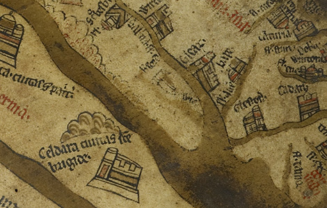
The map is a significant undertaking, its size allowing lots of detail to be drawn within. There are 420 towns shown within and at the centre of the map is Jerusalem, a common feature of T and O maps. East is shown as being at the top of the map, and the Garden of Eden sits up there on the edge of the world. In T and O maps, the Garden of Eden was usually shown as being in Asia, for the sun rises in the East. As well as the Garden of Eden, there are 15 Biblical events depicted on the map, including a drawing of Noah’s Ark, a pathway shown through the Red Sea (which Moses parted) and the Tower of Babel.
The writing on the Hereford Mappa Mundi is made from black ink, but there are also red, gold, blue and green inks used for decoration. There are also 33 animals and plants around the map, including several that were rarely seen in Europe such as elephants and camels. The map is even signed by its creator, “Richard of Aldingham and Lafford” and it is thought that this was a man named Richard de Bello, who was prebend (a type of clergyman) of Lafford in Lincoln Cathedral. Some, though, argue that a map this fine with this much detail could not have been completed by one person, and that Richard of Haldingham and Lafford began the map, it passing to his cousin Richard de Bello upon his death, who then worked on it with his patron Richard Swindfield.
Another point of controversy for many years was the name itself; that the map was not created in Hereford but in fact it was made in Lincoln. Part of this argument stems from the city of Lincoln being depicted in such accurate detail on the map, whilst Hereford is only represented by a single cathedral which looks to have been added in by a different hand. Its identification with Hereford, however, has been confirmed in recent years by an analyses of the frame of the map which shows that the wood originated in or around Hereford.
Despite the high detail of the Hereford Mappa Mundi and its adherence to traditional medieval map forms, the actual geographical aspects of the map do not match knowledge of medieval Europeans of this time. One example is that the Caspian Sea is shown to be connected to the ocean in the upper left of the map, even though decades before the map was made it was confirmed by a Flemish explorer to be landlocked. The map may also be the origin of errors on later maps, as it is the earliest known map to shown the mythical island of St Brendan’s Isle to the west of Northern Africa.
There were several dangers to the survival of the map throughout the centuries, but it was always protected. During the 17th-century Commonwealth the map was hidden from harm underneath the floor of the Chantry. In the 1850s it was sent for cleaning and repair at the British Museum, and a century later during the Second World War it was taken away from the Cathedral, alongside other treasures, to protect it from bomb damage and fire. Though it was looked after in such a way, and despite the map’s global importance today, for many years this importance went unrealised. It was displayed in a glazed case in the north choir aisle of the Cathedral and was considered to be simply a local curiosity.

Enjoying this blog post? Buy me a hot chocolate!
Consider donating the cost of a hot chocolate to me, so I can continue to write and run Just History Posts.
£3.50
In the late 1980s, the Dean and Chapter of Hereford were under huge financial strain. It was identified that the Chapter had significant deficits, for most of its wealth was tied up in its assets. Financial advisors suggested an endowment of at least £6 million should be established to protect it in the future, and this meant selling some of the Chapter’s possessions. It was decided that the Mappa Mundi should be sold, for it was just a single item and would mean the important Chained Library collection could stay intact.
Despite the lack of research on the map showing its true significance, there was immediate local concern about the potential loss of the map and this soon spread to a national stage. After lots of campaigning, the National Heritage Memorial Fund provided a significant cash sum to the newly-formed Mappa Mundi Trust. This money was further added to by Paul Getty – at the time the richest private citizen in the world – and members of the public. With this new fund of money, Hereford Cathedral was able to build a new library building to house the Chained Library and the Mappa Mundi. The treasures could now be displayed for perpetuity at their home.
The Trust has since cared for the map and much more research has been done on it. The map is only removed from its sealed glass cover once every two years so that it can be carefully inspected. During its inspection in 2013, a high-resolution image was made of the map using a 3D scanner, and the map can be digitally explored on the Cathedral’s website.

The Hereford Mappa Mundi is a wonder of medieval Europe. The largest of its kind to survive, it is a fantastic insight into how people in medieval England perceived their world – not just in strict geographical terms, but intertwined with religion and mythology. Its survival across 700 years, through war, turmoil and neglect is a rarity in itself. Its near loss decades ago in fact led to its importance coming to light, and it is now secure for hopefully centuries more to come.
Previous Blog Post: A Brief Moment of History: The WWII Submarine Reindeer
Previous in Historical Objects: Treasures of the Tudors: The Bacton Altar Cloth
List of Blog Posts: here Blog Homepage: here
Buy my books via the pictures below! Or why not check out our shop?


Follow us:

Read more:
https://www.herefordcathedral.org/mappa-mundi
https://www.themappamundi.co.uk/about-the-trust.php
https://www.themappamundi.co.uk/index.php
https://www.themappamundi.co.uk/mappa-mundi/

4 responses to “Historical Objects: The Hereford Mappa Mundi”
[…] Historical Objects: The Hereford Mappa Mundi — Just History Posts […]
LikeLike
[…] Previous Blog Post: Historical Objects: The Hereford Mappa Mundi […]
LikeLike
[…] Previous in Historical Objects: The Hereford Mappa Mundi […]
LikeLike
[…] Hereford Mappa Mundi, created c1300, which has mythical creatures around its […]
LikeLike